Home       Firsts      Index, Chronological       Index, Subject      1800-1849     1850-1879      1880-1899   1900-1919      1920-1949     1950-1979     1980-1999     2000-2009     2010-2019                


1800 - 1849 Historic Dates in San Bernardino and The Railroad:


Wednesday
Jan012014

January 18, 1803 - Corps of Discovery


January 18, 1803U.S. President Thomas Jefferson sent a secret message to Congress asking for approval and funding of an expedition to explore the Western part of the continent.  

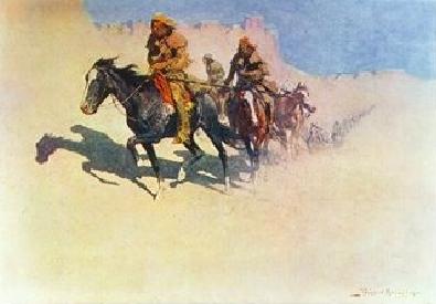
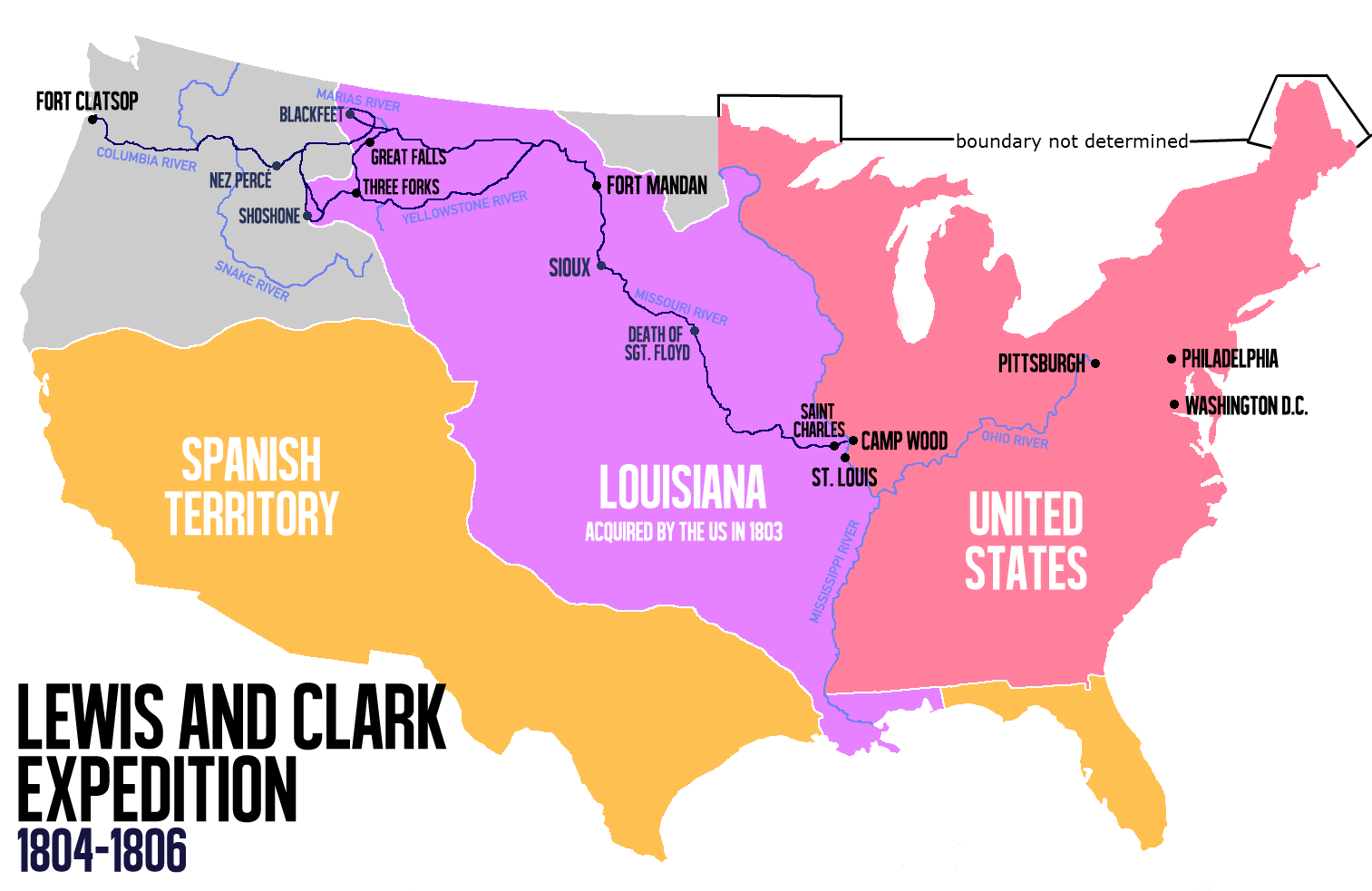
Thomas Jefferson sent Lewis and Clark's Corps of Discovery to find a water route to the Pacific and explore the uncharted West. He believed woolly mammoths, erupting volcanoes, and a mountain of pure salt awaited them. What they found was some 300 species unknown to science, nearly 50 Indian tribes, and the Rockies. 

July 4, 1803 - News of the Louisiana Purchase is announced; Meriwether Lewis as the expedition's leader, who had been training in Philadelphis, will now be exploring land largely owned by the United States.

Summer 1803 - Lewis oversees construction of a keelboat in Pittsburg, then picks up William Clark and other recruits as he travels down the Ohio River.  Lewis and Clark establish their winter camp on the Wood River, IL.

May 14, 1804 - The Corps of Discovery leaves Camp Wood and begins its journey up the Missouri River.

October 24, 1804 - Near today's Bismarck, North Dakota, the Corps arrives at the villages of the Mandan and Hidatsa, buffalo-hunting tribes that live along the Missouri River.

November 4, 1804 - Lewis and Clark hire French-Canadian fur-trader Toussaint Charbonneau and his Shoshone wife, Sacagawea, to act as interpreters on the journey ahead.

December 24, 1804 - The men build Fort Mandan, their winter quarters in present-day North Dakota.

June 13, 1805 - Lewis reaches the Great Falls of the Missouri—five massive cascades around which the men must carry all of their gear, including the canoes.

September 11, 1805 - The Corps begins the steep ascent into the Bitterroot Range of the Rocky Mountains with horses acquired from the Shoshone; the crossing will cover more than 160 miles.

September 23, 1805 - Starving, the men emerge from the mountains near present-day Weippe, Idaho, at the villages of the Nez Perce Indians, who teach them a new method of making dugout canoes.

October 7, 1805 - The men push off down the Clearwater River near Orofino, Idaho; it is the first time they've traveled with the current at their back in almost two years.

November 24, 1805 - Having reached the Pacific, the men built their winter quarters on the Clatsop Indian side of the Columbia River, and the encampment came to be called Fort Clatsop.

March 23, 1806 - After a winter of only 12 days without rain, the men set out for home.

September 23, 1806 - Having found an easier route across the country, the men reach St. Louis nearly two and a half years after their journey began and are acclaimed as national heroes.

(excerpts from National Geographic)

Sunday
Jan052014

February 21, 1804 - World's First Steam Locomotive

Above is an 1/2 inch scale model (built in 1888) of Richard Trevithick's 1804 locomotive. Courtesy of the National Museum of American History.

It represents the world's first steam powered locomotive used for transportation on rails.    

On February 21, 1804, Richard Trevithick's unnamed steam locomotive hauled a train with five loaded cars along the tramway of the Penydarren Ironworks, in Merthyr Tydfil, Wales.         

Richard Trevithick (1771 – 1833) was a British inventor and mining engineer from Cornwall, England. His most significant contributions were the development of the first high-pressure steam engine and the first full-scale working railroad steam locomotive.

Friday
Jan102014

May 20, 1810 - Naming San Bernardino

Typical enramada, a structure used by 19th Century Spanish missionaries as a chapel while searching for a location for a new rancho or mission.

In 1774, Juan Batista de Anza passed through San Bernardino Valley (calling it "Valle de San Joseph") enroute to San Gabriel.   The question is...what is the origin of the name "San Bernardino"?

In 1930, George William Beattie published Calfornia's Unbuilt Missions in which he says the Spanish missionaries started to establish new missions at: Santa Isabel, San Antonio de Pala & San Bernardino.

In 1902, Father Juan Caballeria wote in his book, History of San Bernardino Valley, from the Padres to the Pioneers, 1810-1851, ..."a party of missionaries, soldiers and Indian neophytes of San Gabriel mission, under the leadership of Padre Dumetz, were sent out to select a location [for a supply station].  On the 20th of May, 1810, they came into the San Bernardino Valley.  This, according to the Roman Calendar of Saints, was the feast day of San Bernardino of Sienna and they named the valley in his honor."

In 1823, Jose M. Narvaes, a Spanish cartographer, lists, "Bernardino" as a Rancheria on his map, Carta esferica de los territorios de la alta y baja Californias y estado de Sonora.

In 1832, Thomas Coulter, an Irish botanist, discussed "San Bernardino Peak" and "Rancho San Bernardino" in his writings.  His 1832 California map accurately depicts the location of "S. Bernardino".

In 1839, David Burr, Geographer to the House of Representatives of the U. S., published a map of the United States which includes the words, "San Bernardino", that are properly positioned on the map.

In 1842, Governor Alvarado granted "Rancho San Bernardino" to Jose de Carmen Lugo and relatives.

In 1851, the Mormons purchased "Rancho San Bernardino" fron Lugo.

In 1853, the County of San Bernardino was created; in 1854, the City of San Bernardino incorporated.

So, if it was not Father Dumetz in 1810, then somebody else of high rank or position had to name the valley "San Bernardino" in the early years of the 19th century.  

Note: For related stories see "May 20, 1910"; "May 20, 1960" and "May 20, 2010".

Monday
Feb102014

1819 to 1820 - Mill Creek Zanja


The Mill Creek Zanja (an irrigation ditch), shown here in a photograph from around 1890, was built by local Indians in 1819-1820.

For many years the padres at Mission San Gabriel (established in 1771) were interested in locating a ranch, and eventually a mission, in the San Bernardino Valley.  The opportunity did not arise until 1819, when the Indians at Guachama Rancheria asked the padres at Mission San Gabriel to teach them agriculture and stock raising.

Guachama Rancheria was an Indian village of 200-500 Native Americans located along what is now Mission Road, between California Street and Mountain View Avenue, in Loma Linda.  The area has also been referred to as Old San Bernardino or Cottonwood Row.

The first step in creating a thriving ranch was to bring water to the area.  This was done by digging a 12-mile zanja (an irrigation ditch) from Mill Creek, near what is now Mentone, down through Redlands and westward to Loma Linda.  

Construction of the zanja was done by Native Americans under the direction of Pedro Alvarez.  In 1820 a residence for a mayordomo (overseer) was built and Carlos Garcia became responsible for managing the flow of water and maintaining and repairing the zanja.

In his 1821 diary, Father Jose Sanchez writes that Rancho San Bernardino, "was well stocked, with a small cultivated area, and buildings used for storage and residence by the first mayor-domo".

Mill Creek Zanja is the oldest irrigation ditch in the county and for a long time supported San Gabriel Mission's ranch and estancia, as well as local farms and numerous industries that relied upon it's water.

Mill Creek Zanja is listed on the National Register of Historic Places and is California Register Landmark No. 43.

The western half of the zanja has been covered over.  The Redlands Conservancy's Save the Zanja Committee plans to develop a natural-surface trail and greenway along or near the historic Zanja, from Ninth Street in downtown Redlands east to Mentone.  Completion is expected by 2019, in time for the Zanja's bicentennial.

Note:  For additional information see: Mill Creek Zanja, Driving Tour and Brief History by Tom Atchley, 2009.

Wednesday
Feb122014

September 23, 1821 - Jumuba (Fort Benson)


The above plaque is titled, Fort Benson, however it probably should be named, Jumuba, instead.

Jumuba is not a familiar name, but it has been involved in San Bernardino Valley history from the prehistoric through the mission, rancho, Mormon, and post Mormon eras.

Jumuba was the Indian rancheria (village) at a group of three springs on the West side of Hunts Lane, between Redlands Boulevard and the railroad tracks.

In 1821 Fathers Payeras and Sanchez traveled from San Diego to San Gabriel seeking new mission sites. The diary of Father Sanchez includes observations made in the San Bernardino Valley on September 23, 1821, and the first written mention of the Jumuba rancheria

Six years later, trapper Jedediah Smith and his party camped at Jumuba for more than a week in 1827 while supplies were being assembled.

After the San Bernardino Mission Rancho was granted to the Lugos and Diego Sepulveda in 1842, Jose Maria Lugo built his adobe house near the three springs of Jumuba.

Several pioneers squatted on land, which they hoped the Mormons would not claim.  One of these was Jerome Benson, who settled at Jumuba in 1856.  Benson was ordered to move, but he refused.  He and other Independents fortified Benson's adobe barn with a cannon and it was dubbed Fort Benson.  However, the fort was never attacked and Benson remained at Jumuba.

Ambrose Hunt and George Cooley arrived in the area in 1857.  Hunt acquired the Benson property and proceeded to develop it into a very successful farm.  (Hunt's Lane is named after Ambrose Hunt, not Jefferson Hunt.)

About the time the Freeway was built, the whole area was bulldozed, destroying trees and the three springs.  In 1957 the House Grain Company bought the land, built a grain elevator and on Hunt's Lane built an office and a truck scale.

The above plaque was preserved and remounted beside the office.  The site is registered as State Historical Landmark #617.

Saturday
Feb152014

1823 - "Bernardino" on the Map

                                                                                                                                                                                                                                                                                                                     
This is a small portion of an 1823 map of Mexico created by Jose Maria Narvaes.  It is titled, Carta esferica de los territorios de la alta y baja Californias y estado de Sonora.

This was the first time that "Bernardino" was annotated on a map.                                                                                                                                                 
The symbol to the left of Bernardino is that of a "rancheria".  The Spanish word rancheria refers to a small Indian settlement or is used to designate the workers' quarters of a ranch.  The term also describes a type of communal settlement formerly characteristic of the Yaqui Indians of Sonora, Mexico.

As the range of the California missions spread many of these small rancherias expanded into huge ranchos containing thousands of livestock and hundreds of acres of crops.

For example, the Bernardino Rancheria, formerly known as the Guachama Rancheria, (located on what is now Mission Road in Loma Linda) became Rancho San Bernardino of Mission San Gabriel.  Two other ranchos in the San Bernardino Valley, i.e., Rancho Agua Caliente and Rancho Jumuba, also belonged to Mission San Gabriel.

In 1842, Governor Alvarado granted Rancho San Bernardino to Jose de Carmen Lugo and relatives, who then sold it to the Mormons nine years later.  Rancho San Bernardino evolved into the City of San Bernardino (incorporated in 1854).

Note: To view the entire map click on the above map or visit the Library of Congress site at http://www.loc.gov/resource/g4300.mf000071/

Monday
Feb172014

September 27, 1825 - World's First Passenger Train

The above image was copied from "The History of Transportation", a small book published by the Railway Education Bureau in 1927.

On September 27, 1825, Locomotion No. 1 became the world's first steam locomotive to carry passengers on a public line, the Stockton and Darlington Railway, in North East England.

Locomotion No. 1 was built by George Stephenson at his son Robert's company, the Robert Stephenson and Company.

George Stephenson drove the first train. The engine was called Active (later renamed Locomotion). It pulled a train with 450 passengers at a speed of 15 miles an hour.

George Stephenson (9 June 1781 – – 12 August 1848) was a self made mechanical engineer, largely credited with building the first railway line and becoming the ‘father of the railways’.

His rail gauge of 4 feet 8.5 inches became the global standard gauge for most of the world's railways.

George also built the first public inter-city railway line in the world to use locomotives, the Liverpool and Manchester Railway, which opened in 1830. 

Stephenson's "Locomotion No. 1" can be seen at the Darlington Railway Centre and Museum, located in an original 1840s railway station.

Wednesday
Feb192014

August 22, 1826 - Jedediah Smith

Jedediah Smith and Men in the Mojave Desert in 1826 (c.1905 by Frederic Remington)

"The first American to describe the San Bernardino Valley was a member of the fur trapping expedition which came this way in 1826.  The diarist's name was Harrison G. Rogers.

"Anxious to explore the country between the Rocky Mountains and the Pacific Ocean, Rogers was one of 18 mountain men led by 27 year old Jedediah Strong Smith.  The party left northern Utah on August 22, 1826 and traveled southerly to the Mohave villages near the Colorado River.

"They followed the Mohave Indian Trail from Soda Lake to the San Bernardino Mountains before tromping down into the wide San Bernardino Valley.  After a brief stopover, the ragged, dirty, and half-starved band of trappers headed for Mission San Gabriel, where they arrived on November 7, 1826.  Jedediah Smith and his men had become the first Americans to reach California by the overland route.

"The Smith party was detained for over two months while Governor Jose Maria Echeandia investigated the reasons why these uninvited guests arrived.  California was still under Mexican rule, and any report of "foreigners" entering from the east was disturbing to say the least.

"The trappers resumed their journey on January 17, 1827 and headed back to the San Bernardino Valley. This time their layover was for more than a week.  They camped at "Jumuba", an Indian village located [just south of todays Redlands Boulevard and west of Hunts Lane]...

"While gathering supplies and breaking wild horses, it was at this camp that Rogers wrote his impressions of the climate, recorded the trouble that the men experienced because of horses running away and mentioned about the Indians in the San Bernardino Valley."

   (From the writings of Nicholas R. Cataldo) 

Monday
Mar102014

January 28, 1830 - Old Spanish Trail

In 1821 Mexico gained independence from Spain and eight years later traders from New Mexico, began the long trek to Los Angeles, California, to exchange goods and return to New Mexico where they could sell them for a profit. 

They carried woolen goods and a variety of animal hides to exchange for California horses and mules.

The first caravan, led by Antonio Armijo, traveled about three months from Abiquiu (Northwest of Santa Fe, New Mexico) to reach Southern California.  They crossed the Cajon Pass and reached San Bernardino on January 28, 1830, and here they rested for the remainder of the day before proceeding to Mission San Gabriel and Pueblo de Los Angeles.  

This was the first of many caravans on what soon became known as the Old Spanish Trail.

Click here for the National Park Service brochure on the Old Spanish Trail.

Saturday
Mar152014

August 28, 1830 - "Tom Thumb"

      "Tom Thumb", 0-4-0 Steam Locomotive

*  This is the first successful steam locomotive built in America.

*  It was built by Peter Cooper for the B&O Railroad.

*  Previously the Baltimore & Ohio Railroad relied on horses to pull its passenger and freight trains.

*  This locomotive had an upright boiler, short wheelbase and a geared drive.

*  On August 28, 1830, "Tom Thumb" carried the B&O directors in a passenger car to Ellicott's Mills.

*  It hauled passengers until March 1831, but was never put into regular service.

*  It was salvaged in 1834.  As it was a demonstration engine, no engineering drawings of it exist.

(extracted from the B&O Railroad Museum website) 

Above is a Replica of the "Tom Thumb" located in the B&O Railroad Museum

Click here to see a photo history of other early steam locomotives.

Thursday
Mar202014

March 9, 1835 - "S. Bernardino" on a California Map

1832 Map of California

The "Notes on Upper California, A Journey from Monterey to the Colorado River in 1832", by Dr. Thomas Coulter was presented to the Royal Geographic Society of London, March 9, 1835.

In addition to the text, there was Dr. Coulter's 1832 Map of California.  This was the first time that the words, "S. Bernardino" were included on a map of California.  

Thomas Coulter discusses San Bernardino Peak and Rancho San Bernardino in his Notes on Upper California and published a map that accurately depicts the location of San Bernardino.  He stated,

"The only settled portion of Upper California lies along the coast; the missions being nearly all within one day's journey from it. The only point where a mission that has any settlement further inland is at San Gabriel, where the Rancho of San Bernardino is at the head of the valley, some thirty leagues [ninety miles] from the port of San Pedro. This is indeed the only point of either Californias, south of San Francisco, capable of sustaining a large population."


Note that in 1832 Los Angeles is listed as a "Pueblo" yet the islands and missions are properly named.

Tuesday
Apr012014

July 10, 1839 - "San Bernardino" on U.S. Map

1839 Map of the U. S.

This map was created by David H. Burr, Geographer to the House of Representatives of the U. S., and was entered in the Clerk's Office of the District Court of the District of Columbia, July 10, 1839.

This is the first time the words, "San Bernardino", appeared on a U. S. map.

⬅︎

San Bernardino is located in the center of the map just above the dark horisontal line.

The routes traveled by Jedediah Smith in 1826 and 1827 are also annotated on this map.


Note: To view the entire map of the United States click on the above map or visit the Library of Congress site at http://www.loc.gov/resource/g3700.rr000060/

Saturday
Apr052014

June 21, 1842 - Lugo Map of Rancho San Bernardino


Rancho San Bernardino was created by Mission San Gabriel in 1819.  In 1821, Spain relinquished control of Mexico, including Alta and Baja California.  All of the Calfornia missions were "secularized" (confiscated) beginning in 1834 and Mexico began approving grants of mission lands to political favorites.

Don Antonio Maria Lugo, was a wealthy land owner in the Los Angeles area when he requested a land grant, covering  35,509 acres in the San Bernardino and Yucaipa valleys, for his three sons and a nephew.  It was immediately granted by Governor Juan Bautista Alvarado, his grandnephew.  

On June 21, 1842, Governor Alvarado granted the Lugos permanent possession of the land, meaning that they could live on the land and deny anyone but the original Indians the right to remain on the the land.

The three Lugo boys and a cousin were to start colonizing this land by building homes and transferring livestock to the area.  Some Spanish terms indicated on the map include: 

Saca de agua is the Mill Creek Zanja

Ojos de agua is Arrowhead Springs.

Casa de Lugo, the Lugo house is shown at the intersection of the compass lines [on what is now the 1926 courthouse grounds].

Jacal Jumuba, for former keepers of mission cattle.  José María Lugo built an adobe home near the springs at Jumuba [West of Hunts Lane and South of Redlands Blvd.].

Casa arruinadas, mission rancho headquarters and the Assistencia [Estancia], became the home of José del Carmen Lugo [Barton Road and Nevada Street in Redlands].

Casa de Sepulveda in Yucaipa, home of the Lugos' cousin, Diego Sepulveda.

Vicente Lugo built an adobe near De Sienna Springs and Bunker Hill [near Inland Center Drive and I Street].

The Lugos did not succeed in colonoizing the area and eventually sold Rancho San Bernardino to the Mormon Church in 1851 for $77,500.

Sunday
Apr062014

July 4, 1842 - First U.S. Flag in San Bernardino


In 1842 a United States flag of this design was flown over San Bernardino for the first time.  At the time there were only 26 states in the Union, while California was governed by Mexico.  It was not until September 9, 1850, that California became the 31st state.

    The First Fourth of July Celebration

in San Bernardino

    Daniel Sexton had arrived in Old San Bernardino in      December of 1841, and went to work in the mountains  above Cherry Valley cutting timber for Isaac Williams of  the  Chino Rancho and others.  Cahuilla Indians furnished  the  labor for the operation at a wage of 25 cents per  day.  Sexton made friends with the Indians and gained  much  influence with them, eventually marrying the niece  of  Chief  Solano.  In 1842 they asked him if the  Americans  did not  celebrate feast days.  In response, on  July 4, 1842,  Sexton  erected a flag pole and raised an  American  flag  over  the  camp,  and  celebrated  along  with the Indians in  a  patriotic  fashion.  

- excerpt from an  article by Arda M. Haenszel